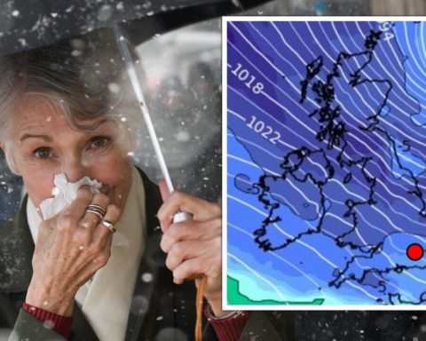
Britons are bracing for blustery winds and even gales in the far north until the end of January after a freezing cold weekend, forecasters predict. Weather prediction maps from Net Weather TV show Northern Scotland will experience highly windy conditions, with frontal rain passing through, sleet and snow on higher ground, and strong gusts.
As low pressure pulls away, there will occasionally be strong winds and high gusts that will hit northern Britain, especially northeastern England, the Pennines, and eastern Scotland. These gusts of wind could go over 50mph, according to the Met Office. According to NWP prediction maps, wind could blow at 70mph.
Strong, gusty winds will hit the northern half of the UK on Monday, Tuesday, and Tuesday night, bringing wild weather to the Northern Isles, Highland, and Grampian.
The jet stream will blast out of Northern America, where extreme cold warnings have been issued in Canada due to a plunge of Arctic air.
This temperature difference assists a stronger jet, and a massive frontal system is expected to move across the United States this weekend. Heavy snow, dangerous wind chill, heavy rain, and flash flooding are all expected.
The zonal jet will move across the northern Atlantic, bringing low pressures from Iceland to Norway, and, as it moves south, windier conditions will affect the UK next week.
Forecasters don’t expect much snow because we don’t have the Arctic air surge. While cold fronts hang off of these passing lows or in showery flows behind the fronts, sleet and hill snow are predicted.
READ MORE: State pensioners could be eligible for £475 a year in energy support
Temperatures will seem colder, and over high ground, the rains will turn snowy. Flurries may be expected early on Monday and again Tuesday evening in places exposed to the northwest. Most places will get a lot of dry, sunny weather, however, western coastlines may occasionally experience sprinkles of rain.
Jo Farrow, Net Weather forecaster and STV broadcast meteorologist said: “Next week is going to be windier for everyone. We have had some very steady settled weather across the United Kingdom - high pressure has been nearby and that’s been anchoring our UK weather, especially that cold pool of air that’s brought the frost and the freezing fog of Southern Britain.
“Now with more breeze, we won’t see the temperature falling as much by night and also it should keep the frost at bay.
DON’T MISS:
Elton John ‘heartbroken’ as gig axed last minute due to ’emergency’ [REPORT]
Snow showers to lash parts of UK this weekend amid blizzard fears [REPORT]
Naga Munchetty exposes Carol Kirkwood’s wardrobe habit [REPORT]